SOIL SCIENCE*
|
space for advertisements |
Discussion on Soil Science
Areas of Practice
Academically, soil scientists tend to be drawn to one of five areas of specialization: microbiology, pedology, edaphology, physics or chemistry. Yet the work specifics are very much dictated by the challenges facing our civilization's desire to sustain the land that supports it, and the distinctions between the sub-disciplines of soil science often blur in the process. Soil science professionals commonly stay current in soil chemistry, soil physics, soil microbiology, pedology, and applied soil science in related disciplines.
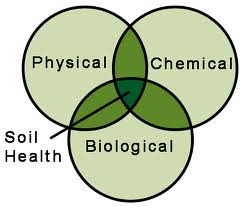
One interesting effort drawing in soil scientists in the USA as of 2004 is the Soil Quality Initiative. Central to the Soil Quality Initiative is developing indices of soil health and then monitoring them in a way that gives us long term (decade-to-decade) feedback on our performance as stewards of the planet. The effort includes understanding the functions of soil microbiotic crusts and exploring the potential to sequester atmospheric carbon in soil organic matter.
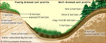
A more traditional role for soil scientists has been to map soils. Most every area in the United States now has a published soil survey, which includes interpretive tables as to how soil properties support or limit activities and uses. An internationally accepted soil taxonomy allows uniform communication of soil characteristics and functions. National and international soil survey efforts have given the profession unique insights into landscape scale functions. The landscape functions that soil scientists are called upon to address in the field seem to fall roughly into six areas:
1. Land based treatment of wastes
2. Identification and protection of environmentally critical areas
3. Management for optimum land productivity
-Water mangement
4. Management for optimum water quality
5.Remediation and restoration of damaged land
6. Sustainability of desired uses
Practical Applications
A. Radiometric dating: specifically a knowledge of local pedology is used to date prior activity at a site.
Land slides
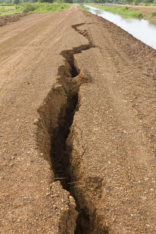
A landslide or landslip is a geological phenomenon which includes a wide range of ground movements, such as rockfalls, deep failure of slopes and shallow debris flows, which can occur in offshore, coastal and onshore environments. Although the action of gravity is the primary driving force for a landslide to occur, there are other contributing factors affecting the original slope stability. Typically, pre-conditional factors build up specific sub-surface conditions that make the area/slope prone to failure, whereas the actual landslide often requires a trigger before being released
Active faults
An active fault is a fault that is likely to have another earthquake sometime in the future. Faults are commonly considered to be active if there has been movement observed or evidence of seismic activity during the last 10,000 years. Active faulting is considered to be a geologic hazard and related to earthquakes as a cause. Effects of movement on an active fault include strong ground motion, surface faulting, tectonic deformation, landslides and rockfalls, liquefaction, tsunamis and seiches. Quaternary faults are those active faults that have been recognized at the surface and which have evidence of movement in the past 1.6 million years. That is the duration of the Quaternary Period.
B. Altering soils to achieve new uses
"The process of removing carbon from the atmosphere and depositing it in a reservoir. When carried out deliberately, this may also be referred to as carbon dioxide removal, which is a form of geoengineering. The process of carbon capture and storage, where carbon dioxide is removed from flue gases, such as on power stations, before being stored in underground reservoirs. Natural biogeochemical cycling of carbon between the atmosphere and reservoirs, such as by chemical weathering of rocks. Carbon sequestration describes long-term storage of carbon dioxide or other forms of carbon to either mitigate or defer global warming and avoid dangerous climate change. It has been proposed as a way to slow the atmospheric and marine accumulation of greenhouse gases, which are released by burning fossil fuels. Carbon dioxide is naturally captured from the atmosphere through biological, chemical or physical processes. Some anthropogenic sequestration techniques exploit these natural processes, while some use entirely artificial processes.
C. Environmental Soil Science
Environmental soil science is the study of the interaction of humans with the pedosphere as well as critical aspects of the biosphere, the lithosphere, the hydrosphere and the atmosphere. Environmental soil science addresses both the fundamental and applied aspects of the field including: buffers and surface water quality, vadose zone functions, septic drain field site assessment and function, land treatment of wastewater, stormwater, erosion control, soil contamination with metals and pesticides, remediation of contaminated soils, restoration of wetlands, soil degradation, nutrient management, movement of viruses and bacteria in soils and waters, bioremediation, application of molecular biology and genetic engineering to development of soil microbes that can degrade hazardous pollutants, land use, global warming, acid rain, and the study of anthropogenic soils, such as terra preta.
D. Field Application in Soil Science
• Soil survey
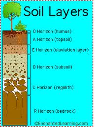
Soil survey or soil mapping, is the process of classifying soil types and other soil properties in a given area and geo-encoding such information. It applies the principles of soil science and draws heavily from geomorphology, theories of soil formation, physical geography, and analysis of vegetation and land use patterns. Primary data for the soil survey are acquired by field sampling and by remote sensing. Remote sensing principally uses aerial photography, but other digital techniques are steadily gaining in popularity. In the past, a soil scientist would take hard-copies of aerial photography, topo-sheets, and mapping keys into the field with them.
Soil survey components
• a brief overview of the county's geography
• a general soil map with a brief description of each of the major soil types found in the county along with their characteristics
• detailed aerial photographs with specific soil types outlined and indexed
• photographs of some of the typical soils found in the area
• tables containing general information about the various soils such as total area, comparisons of production of typical crops and common range plants. They also include extensive interpretations for Land use planning such as limitations for dwellings with and without basements, shallow excavations, small commercial buildings, septic tank adsorptions, suitability for development, construction, and water management.
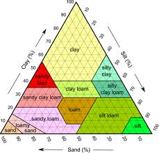
• tables containing specific physical, chemical, and engineering properties such as soil depth, soil texture, particle size and distribution, plasticity, permeability, available water capacity, shrink-swell potential, corrosion properties, and erodibility.
• Soil management
Soil management practices that affect soil quality:
• Controlling traffic on the soil surface helps to reduce soil compaction, which can reduce aeration and water infiltration.
• Cover crops keep the soil anchored and covered in off-seasons so that the soil is not eroded by wind and rain.
• Crop rotations for row crops alternate high-residue crops with lower-residue crops to increase the amount of plant material left on the surface of the soil during the year to protect the soil from erosion.
• Nutrient management can help to improve the fertility of the soil and the amount of organic matter content, which improves soil structure and function.
• Tillage, especially reduced-tillage or no-till operations limit the amount of soil disturbance while cultivating a new crop and help to maintain plant residues on the surface of the soil for erosion protection and water retention.
Advantages of Soil Management
1) Maintain Soil Fertility
2) Restore Soil Fertility
3) Make the agricultural process an economic one, and
4) Helps increase Yield
*Text has been adapted from Wikipedia.
Academically, soil scientists tend to be drawn to one of five areas of specialization: microbiology, pedology, edaphology, physics or chemistry. Yet the work specifics are very much dictated by the challenges facing our civilization's desire to sustain the land that supports it, and the distinctions between the sub-disciplines of soil science often blur in the process. Soil science professionals commonly stay current in soil chemistry, soil physics, soil microbiology, pedology, and applied soil science in related disciplines.
One interesting effort drawing in soil scientists in the USA as of 2004 is the Soil Quality Initiative. Central to the Soil Quality Initiative is developing indices of soil health and then monitoring them in a way that gives us long term (decade-to-decade) feedback on our performance as stewards of the planet. The effort includes understanding the functions of soil microbiotic crusts and exploring the potential to sequester atmospheric carbon in soil organic matter.
A more traditional role for soil scientists has been to map soils. Most every area in the United States now has a published soil survey, which includes interpretive tables as to how soil properties support or limit activities and uses. An internationally accepted soil taxonomy allows uniform communication of soil characteristics and functions. National and international soil survey efforts have given the profession unique insights into landscape scale functions. The landscape functions that soil scientists are called upon to address in the field seem to fall roughly into six areas:
1. Land based treatment of wastes
- Septic system
- Manure
- Municipal biosolids
- Food and fibre processing waste
2. Identification and protection of environmentally critical areas
- Sensitive and unstable soils
- Dry lands
- Wetlands
- Saline soils, Acid Soils, Alkaline soils
3. Management for optimum land productivity
- Silviculture
- Agronomy
-Water mangement
- Native vegetation
- Grazing
4. Management for optimum water quality
- Storm water management
- Sediments and erosion control
5.Remediation and restoration of damaged land
- Mine reclamation
- Flood and storm damage
- Contamination
6. Sustainability of desired uses
- Soil conservation
Practical Applications
A. Radiometric dating: specifically a knowledge of local pedology is used to date prior activity at a site.
- Stratification (archeology) where soil formation processes and preservative qualities can inform the study of archaeological sites
- Geological phenomena
Land slides
A landslide or landslip is a geological phenomenon which includes a wide range of ground movements, such as rockfalls, deep failure of slopes and shallow debris flows, which can occur in offshore, coastal and onshore environments. Although the action of gravity is the primary driving force for a landslide to occur, there are other contributing factors affecting the original slope stability. Typically, pre-conditional factors build up specific sub-surface conditions that make the area/slope prone to failure, whereas the actual landslide often requires a trigger before being released
Active faults
An active fault is a fault that is likely to have another earthquake sometime in the future. Faults are commonly considered to be active if there has been movement observed or evidence of seismic activity during the last 10,000 years. Active faulting is considered to be a geologic hazard and related to earthquakes as a cause. Effects of movement on an active fault include strong ground motion, surface faulting, tectonic deformation, landslides and rockfalls, liquefaction, tsunamis and seiches. Quaternary faults are those active faults that have been recognized at the surface and which have evidence of movement in the past 1.6 million years. That is the duration of the Quaternary Period.
B. Altering soils to achieve new uses
- Vitrification to contain radioactive wastes
- Enhancing soil microbial capabilities in degrading contaminants (bioremediation).
- Carbon sequestration
"The process of removing carbon from the atmosphere and depositing it in a reservoir. When carried out deliberately, this may also be referred to as carbon dioxide removal, which is a form of geoengineering. The process of carbon capture and storage, where carbon dioxide is removed from flue gases, such as on power stations, before being stored in underground reservoirs. Natural biogeochemical cycling of carbon between the atmosphere and reservoirs, such as by chemical weathering of rocks. Carbon sequestration describes long-term storage of carbon dioxide or other forms of carbon to either mitigate or defer global warming and avoid dangerous climate change. It has been proposed as a way to slow the atmospheric and marine accumulation of greenhouse gases, which are released by burning fossil fuels. Carbon dioxide is naturally captured from the atmosphere through biological, chemical or physical processes. Some anthropogenic sequestration techniques exploit these natural processes, while some use entirely artificial processes.
C. Environmental Soil Science
Environmental soil science is the study of the interaction of humans with the pedosphere as well as critical aspects of the biosphere, the lithosphere, the hydrosphere and the atmosphere. Environmental soil science addresses both the fundamental and applied aspects of the field including: buffers and surface water quality, vadose zone functions, septic drain field site assessment and function, land treatment of wastewater, stormwater, erosion control, soil contamination with metals and pesticides, remediation of contaminated soils, restoration of wetlands, soil degradation, nutrient management, movement of viruses and bacteria in soils and waters, bioremediation, application of molecular biology and genetic engineering to development of soil microbes that can degrade hazardous pollutants, land use, global warming, acid rain, and the study of anthropogenic soils, such as terra preta.
D. Field Application in Soil Science
• Soil survey
Soil survey or soil mapping, is the process of classifying soil types and other soil properties in a given area and geo-encoding such information. It applies the principles of soil science and draws heavily from geomorphology, theories of soil formation, physical geography, and analysis of vegetation and land use patterns. Primary data for the soil survey are acquired by field sampling and by remote sensing. Remote sensing principally uses aerial photography, but other digital techniques are steadily gaining in popularity. In the past, a soil scientist would take hard-copies of aerial photography, topo-sheets, and mapping keys into the field with them.
Soil survey components
• a brief overview of the county's geography
• a general soil map with a brief description of each of the major soil types found in the county along with their characteristics
• detailed aerial photographs with specific soil types outlined and indexed
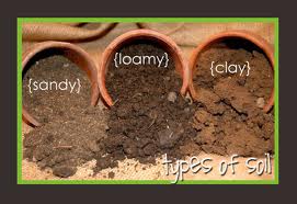
• photographs of some of the typical soils found in the area
• tables containing general information about the various soils such as total area, comparisons of production of typical crops and common range plants. They also include extensive interpretations for Land use planning such as limitations for dwellings with and without basements, shallow excavations, small commercial buildings, septic tank adsorptions, suitability for development, construction, and water management.
• tables containing specific physical, chemical, and engineering properties such as soil depth, soil texture, particle size and distribution, plasticity, permeability, available water capacity, shrink-swell potential, corrosion properties, and erodibility.
• Soil management
Soil management practices that affect soil quality:
• Controlling traffic on the soil surface helps to reduce soil compaction, which can reduce aeration and water infiltration.
• Cover crops keep the soil anchored and covered in off-seasons so that the soil is not eroded by wind and rain.
• Crop rotations for row crops alternate high-residue crops with lower-residue crops to increase the amount of plant material left on the surface of the soil during the year to protect the soil from erosion.
• Nutrient management can help to improve the fertility of the soil and the amount of organic matter content, which improves soil structure and function.
• Tillage, especially reduced-tillage or no-till operations limit the amount of soil disturbance while cultivating a new crop and help to maintain plant residues on the surface of the soil for erosion protection and water retention.
Advantages of Soil Management
1) Maintain Soil Fertility
2) Restore Soil Fertility
3) Make the agricultural process an economic one, and
4) Helps increase Yield
*Text has been adapted from Wikipedia.
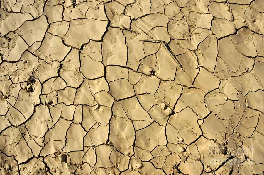
Pictures of Soil Science
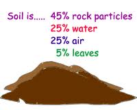
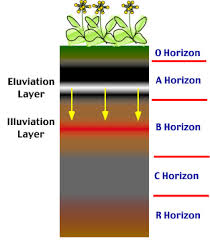
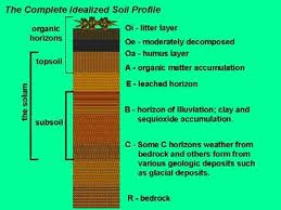
Broad Categories of Soil Science
© BiNET 2008-2014 | Terms of use, privacy and disclaimer | Help us to improve
